NavCom Now Offers Carlson Software as an Option for Its LAND-PAK Survey System
"It's everything a new company or survey department needs."
TORRANCE, Calif.--NavCom Technology, Inc., a wholly owned subsidiary of Deere & Company (NYSE:DE), announced the addition of Carlson's SurvCE data collection software and Carlson Survey 2013 as a software option to its more complete LAND-PAK™ Survey System.
"LAND-PAK is a turn-key StarFire/RTK survey solution that now offers the choice of Carlson Software for field and office work," said Steve Ault, NavCom's Product Manager. "This allows our customers the choice to customize their LAND-PAK - to select which software tool works best for them - to get the job done right."
"The NavCom LAND-PAK bundle is the first time Carlson has worked with a major manufacturer to bundle not just SurvCE but also Carlson Survey, our office survey solution that is a virtual standard in the U.S. survey industry," said Bruce Carlson, president of Carlson Software. "This powerful combination means that purchasers of NavCom GNSS products can conduct their field work efficiently and then take the data seamlessly into Carlson Survey to quickly complete their as-built, topo map, subdivision or survey plat deliverables. NavCom's LAND-PAK is a great concept, long overdue," he added. "It's everything a new company or survey department needs."
The LAND-PAK system includes full GNSS receiver support, field, office & GNSS post processing software, all hardware & accessories, plus an online video training library and comes with an industry leading three year manufacturer's warranty. LAND-PAK also includes a lifetime license for our StarFire global satellite-based augmentation system providing 5 centimeter horizontal accuracy worldwide and the freedom and flexibility that a DGPS solution offers in addition to its proprietary Ultra RTK and RTK-Extend features that allow for RTK level accuracy over extended baselines and during communication outages.
LAND-PAK is available through NavCom's dealer network. For additional product information, visit www.LAND-PAK.com or contact NavCom's Sales team at +1 (310) 381-2000 or sales@NavComTech.com. LAND-PAK will be governed by NavCom's standard terms and conditions.
About NavCom Technology, Inc.
NavCom Technology, Inc., a John Deere Company (NYSE:DE), is a leading provider of advanced GNSS products for OEMs, VARs, and system integrators requiring high performance RTK systems, global decimeter level GNSS satellite corrections, geodetic quality GNSS receivers and engineering consulting in the areas of precise positioning, wireless communications and robotics. For more information on NavCom Technology and its products, please visit www.NavComTech.com.
About Carlson Software, Inc.
Founded in 1983, Carlson Software, Inc. is a leading provider of office and field software for land development markets, including land surveying, civil engineering, mining, construction, accident reconstruction and machine control. Carlson Software is headquartered in Maysville, Ky., U.S.A.
Featured Product
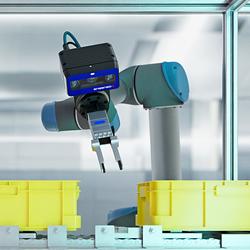
3D Vision: Ensenso B now also available as a mono version!
This compact 3D camera series combines a very short working distance, a large field of view and a high depth of field - perfect for bin picking applications. With its ability to capture multiple objects over a large area, it can help robots empty containers more efficiently. Now available from IDS Imaging Development Systems. In the color version of the Ensenso B, the stereo system is equipped with two RGB image sensors. This saves additional sensors and reduces installation space and hardware costs. Now, you can also choose your model to be equipped with two 5 MP mono sensors, achieving impressively high spatial precision. With enhanced sharpness and accuracy, you can tackle applications where absolute precision is essential. The great strength of the Ensenso B lies in the very precise detection of objects at close range. It offers a wide field of view and an impressively high depth of field. This means that the area in which an object is in focus is unusually large. At a distance of 30 centimetres between the camera and the object, the Z-accuracy is approx. 0.1 millimetres. The maximum working distance is 2 meters. This 3D camera series complies with protection class IP65/67 and is ideal for use in industrial environments.
