senseFly Boosts Farming Efficiency With Launch of eBee Ag Drone for Precision Agriculture
Swiss mini-drone manufacturer senseFly today announces the eBee Ag, a fully autonomous aerial imaging drone (or UAV) for precision agriculture applications.
Cheseaux-Lausanne, Switzerland April 10, 2014
The eBee Ag is the easiest to use and most reliable agriculture drone on the market. Lightweight and highly durable, it features a wide range of camera options and fully autonomous operation - flying, acquiring images, and landing itself.
"The eBee Ag enables growers and coop consultants to become much more precise in their work," says Jean-Christophe Zufferey, C.E.O. of senseFly. "The detail provided by its customised cameras and its software's index calculations allow customers to analyse crop conditions remotely and in high detail. This means less time wasted on manual checks and less reliance on low-resolution satellite images or costly airplane shots. With the accurate and timely data the eBee Ag supplies, farmers can optimise their crop management and chemical usage - saving them time, saving them money, and helping them boost their yields."
4 reasons to choose the eBee Ag:
1. Wide choice of cameras
The eBee Ag features a range of camera options to suit different applications, from biomass estimation to yield monitoring and leaf area indexing. It is supplied with a customized Canon S110 NIR; however, customers can also choose a customised S110 RE (red edge) version, a S110 RGB, or the Airinov multiSPEC 4C (offering four distinct bands with no spectral overlap).
2. Reliable
The eBee Ag's onboard artificial intelligence and robust lightweight construction ensure it will survive numerous flights (and landings), thus safeguarding a customer's investment.
3. Easy to use
The eBee Ag is a fully autonomous drone. Customers simply select the area they want to map (using the supplied eMotion 2 software), launch the drone by throwing it into the air, and the eBee flies, acquires images, and lands all by itself.
4. Complete solution
The eBee Ag is supplied with two advanced software packages: eMotion 2 for flight planning and control; and Postflight Terra 3D photogrammetry software for post-flight image processing and analysis. Postflight Terra 3D can be used to produce false-colour orthomosaics and 3D models. Plus it includes a handy index computation tab, which allows customers to select a band, calculate NDVI, or input custom formulas in order to create the exact maps they require.
With its maximum flight time of 45 minutes, the eBee Ag can photograph areas of up to 1,000 ha (2,470 ac) in a single flight. Its default 12 MP NIR camera is capable of shooting aerial imagery at down to 2 cm (0.7 in) / pixel. These images are then easily transformed into false-colour orthomosaics using Postflight Terra 3D software, with accuracy of down to 3 cm (1.18 in). This market-leading performance brings farmers the data they need to monitor crops more precisely, feed other precision agriculture technologies, and continue improving their management decisions.
Availability: The eBee Ag is available to order from mid-April, 2014 via senseFly's network of approved resellers (see http://www.senseFly.com/about/where-to-buy.html).
Featured Product
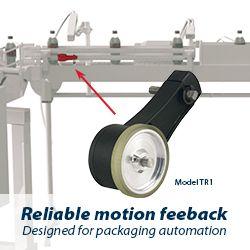
Model TR1 Tru-Trac
The Model TR1 Tru-Trac® linear measurement solution is a versatile option for tracking velocity, position, or distance over a wide variety of surfaces. An integrated encoder, measuring wheel, and spring-loaded torsion arm in one, compact unit, the Model TR1 is easy to install. The spring-loaded torsion arm offers adjustable torsion load, allowing the Model TR1 to be mounted in almost any orientation - even upside-down. The threaded shaft on the pivot axis is field reversible, providing mounting access from either side. With operating speeds up to 3000 feet per minute, a wide variety of configuration options - including multiple wheel material options - and a housing made from a durable, conductive composite material that minimizes static buildup, the Model TR1 Tru-Trac® is the ideal solution for countless applications.
