UAV Manufacturer Draganfly Innovations Inc. Offers Agricultural Remote Sensing Solutions with MicaSense RedEdge Multispectral Camera
Draganfly Innovations Inc. releases an advanced precision agriculture solution that redefines the way agricultural data is collected and viewed. The camera simultaneously captures five discrete spectral bands, which provide useful data for monitoring crops and environmental health.
Saskatoon, SK March 16, 2015
Unmanned aerial vehicles are instrumental in collecting multispectral imaging and provide data rich images, which are not visible to the naked eye. Draganfly Innovations now provides an all-inclusive solution that can plan, fly, and process advanced multispectral data. The Draganflyer Pro-Ag package is a comprehensive and powerful tool for farmers and researchers to gather the information needed to make better decisions.
The Draganflyer Pro-Ag package consists of a compact, ready-to-fly vertical take-off and landing UAV, rugged transport case, Draganfly Surveyor flight planning software, the third generation MicaSense RedEdge 5-band multispectral camera, and 2-axis stabilized gimbal. Built for efficiency, Draganfly Surveyor is easy to use and allows multi-flight mapping in situations when the project requires multiple flights to cover the area. Surveyor will automatically "join" the flights to create one seamless project. Ultimately, its all about acquiring high quality, precise aerial data.
The collected imagery is used to assess the health of crops and identify damage caused by pests or invasive weed growth. The scientific-grade multispectral imagery provides accurate and repeatable crop health maps so that the proper corrective course of action can then be determined. The combination of the MicaSense RedEdge and Draganflyer UAV provides a quick and effective solution for agricultural consultants and farmers worldwide.
Draganfly Innovations Inc., a recognized technology and industry leader in small Unmanned Aircraft Systems (sUAS), is an original manufacturer with over 15 years of experience. Draganfly has partnered with data acquisition industry leaders such as Pix4D to provide aerial mapping, geo-referenced 2D mosaics, 3D surface models, and point clouds. Draganfly systems are used in a wide range of applications for agriculture, public safety, aerial photography & videography, industrial inspection, geo-mapping, and search & rescue work worldwide.
For additional information, contact Draganfly Innovations at 1-800-979-9794, sales(at)draganfly(dot)com, or check out their website at http://www.draganfly.com
Featured Product
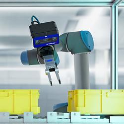
3D Vision: Ensenso B now also available as a mono version!
This compact 3D camera series combines a very short working distance, a large field of view and a high depth of field - perfect for bin picking applications. With its ability to capture multiple objects over a large area, it can help robots empty containers more efficiently. Now available from IDS Imaging Development Systems. In the color version of the Ensenso B, the stereo system is equipped with two RGB image sensors. This saves additional sensors and reduces installation space and hardware costs. Now, you can also choose your model to be equipped with two 5 MP mono sensors, achieving impressively high spatial precision. With enhanced sharpness and accuracy, you can tackle applications where absolute precision is essential. The great strength of the Ensenso B lies in the very precise detection of objects at close range. It offers a wide field of view and an impressively high depth of field. This means that the area in which an object is in focus is unusually large. At a distance of 30 centimetres between the camera and the object, the Z-accuracy is approx. 0.1 millimetres. The maximum working distance is 2 meters. This 3D camera series complies with protection class IP65/67 and is ideal for use in industrial environments.
