LiDAR Mapping Market to Record CAGR of 25% By 2026
The size of LiDAR mapping market was anticipated as USD 900 million in the year 2019 and is predicted to touch $4 billion till 2026, rising with a CAGR of 25% between the years 2020 to 2026 as per the research done by Global Market Insights, Inc.
The size of LiDAR mapping market was anticipated as USD 900 million in the year 2019 and is predicted to touch $4 billion till 2026, rising with a CAGR of 25% between the years 2020 to 2026 as per the research done by Global Market Insights, Inc.
The prevalence of natural disasters like volcanic eruptions, earthquakes and floods is a major factor driving the LiDAR mapping market growth. This is on account of the fact that the rising occurrence of these disasters is increasing the demand for accurate mapping solutions, to reduce risks associated with these natural calamities. Growing population in urban areas is leading to surging need for improved urban planning and rising renovation activities of existing buildings. This factor, in tandem with growing need for modern techniques for surveying archaeological sites is contributing to the popularity of LiDAR mapping solutions across the globe.
LiDAR in mapping requires huge resources that include LiDAR equipment, software, and skilled professionals. The total cost of resources deployed for a single project is high, hindering market growth. Data acquisition requires a long-time period, restraining its deployment on several infrastructure projects.
Increasing emphasis over town planning is anticipated to bolster the significance of LiDAR in mapping technology in the construction & surveying industry. Construction companies are nowadays using LiDAR enabled drones for survey-grade topographic mapping. These drones are capable of operating in difficult terrains and extreme weather conditions. Apart from this, there has been an escalating demand for modern surveying techniques for undertaking archaeological surveys and oil & gas field inspection. Incorporation of such techniques essentially ensures safety to workers.
Construction & surveying application is expected to grow significantly over the forecast timeline due to the rising demand for LiDAR in mapping technology for town planning. The construction companies are using drones equipped with LiDAR technology for survey-grade topographic mapping. This process significantly reduces human risks and operational costs in difficult terrains. Governments across the globe are entering into strategic alliances with prominent market players for several mapping & surveying projects.
LiDAR mapping systems are also gaining traction across countries like India, Japan and China for offering enhanced disaster management solutions. In May 2017, the government of Japan deployed LiDAR mapping systems to evaluate post-disaster damages caused due to Kumamoto earthquake in 2016. This collected data was used for developing strategies to efficiently distribute relief resources during such emergencies. Apart from this, LiDAR in mapping systems are used for geotagging of earthquake sensitive areas and to evaluate the effects of landslides caused by earthquakes.
Evidently, companies like Faro Technologies, Topcon, Fugro and Leica Geosystems are currently at the forefront of LiDAR mapping market. They are focusing on launching low-cost LiDAR sensors to target the growing mapping markets across the globe. In fact, recently LeiShen Intelligent Systems introduced its new series of cost-effective LiDAR sensors, which targeted Chinese SMEs. Companies are also rolling out cutting edge LiDAR sensors and adopting business strategies to meet changing customer demands.
Some major findings of LiDAR mapping market report include:
• The market growth is attributed to the growing demand for improved urban planning due to the rising urban population and the development of smart cities
• The increase in the demand for modern surveying techniques for oil & gas field inspection and archaeological surveys to ensure hazard-free operation is proliferating the adoption of LiDAR mapping tools across the Latin America
• Companies operating in the real-estate sector are increasingly deploying LiDAR mapping technology for ground surveying due to the requirements of high accuracy and precision for the Digital Elevation Model (DEM)
• Leading players operating in the market are Fugro, Faro Technologies, Topcon, and Leica Geosystems
• The drone mapping platform is expected to grow at a significant growth rate due to their ability to operate in difficult terrains and extreme weather conditions
Source: https://www.gminsights.com/industry-analysis/lidar-in-mapping-market
Featured Product
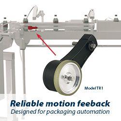
Model TR1 Tru-Trac
The Model TR1 Tru-Trac® linear measurement solution is a versatile option for tracking velocity, position, or distance over a wide variety of surfaces. An integrated encoder, measuring wheel, and spring-loaded torsion arm in one, compact unit, the Model TR1 is easy to install. The spring-loaded torsion arm offers adjustable torsion load, allowing the Model TR1 to be mounted in almost any orientation - even upside-down. The threaded shaft on the pivot axis is field reversible, providing mounting access from either side. With operating speeds up to 3000 feet per minute, a wide variety of configuration options - including multiple wheel material options - and a housing made from a durable, conductive composite material that minimizes static buildup, the Model TR1 Tru-Trac® is the ideal solution for countless applications.
