How drones are helping design the solar power plants of the future
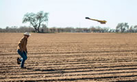 Katie Fehrenbacher for The Guardian: At the edge of a plot of muddy farmland, a few miles down the road from the University of California at Davis, an engineer takes a few quick steps across crop rows and lets go of a three-foot drone. Within seconds, the device – which weighs less than 2lbs and carries a powerful camera – ascends hundreds of feet into the cold, clear, blue sky and begins to snap detailed photos of the ground far below, including a long row of large solar panels mounted on steel poles.
This flight is just a test, demonstrated by Kingsley Chen, the drone fleet coordinator for SunPower at the solar company’s research and development center, which is under construction and about a two-hour drive northeast of the San Francisco Bay Area. The drone will enable SunPower to survey a wide region and help design a solar power farm that can fit more solar panels on a piece of land, more quickly and for lower costs than it previously could. Con'td...
Comments (0)
This post does not have any comments. Be the first to leave a comment below.
Featured Product