How to Improve Surveying Efficiency by Using Robots and Precision Positioning
Case Study - Civ Robotics Teams Up with Point One Navigation to make it much faster and more efficient to do pre-construction surveying.
Point One Navigation has posted a new case study for surveyors and construction industry professionals. https://pointonenav.com/news/civ-robotics-delivering-pinpoint-precision-without-the-hassle/
Managing a construction project from planning stage to execution in the real world is replete with challenges. Whether a company is building a sprawling solar farm or laying lines on the road, precision is paramount. Errors of just a few inches can have massive implications that can lead to critical delays and cost overruns.
In this new case study, Civ Robotics explains how Point One's Polaris RTK precision technology has been instrumental in lowering their operating costs and streamlining processes for many of its high-precision layout projects.
Land surveying is a critical stage in the construction layout process, during which workers use various forms of global navigation satellite systems (GNSS) to mark specific locations for builders. Because this process demands a high degree of precision, all GNSS readings must be validated and corrected to ensure accuracy, sometimes within even a few centimeters.
Historically, this work of verification and layout marking has been done by highly skilled workers manually carrying GPS tools to mark each construction spot, but Civ Robotics is out to change that by using precision layout robots that anyone can operate.
Leveraging Polaris Real-Time Kinematics Network (RTK), Civ's robot rovers can translate construction plans to real-world layout markings that are accurate to within less than a centimeter — and do it with speed. Civ was able to plug-and-go with Polaris RTK, without the hassle of having to set up and calibrate expensive base stations. Liav Muler, the co-founder and chief operating officer of Civ Robotics, said, "It's easy. It's always working. There are no problems."
Where traditional surveyors could mark 200-450 coordinates per day, Civ operators can mark anywhere from 1,200-3,000 points in the same period!
"I think saving money and the simplicity of the product is a big benefit here," said Muler. "Wherever I need an NTRIP (Networked Transport of RTCM via Internet Protocol), Point One is my go-to."
Since bringing its products to market in 2021, Civ Robotics has expedited the land surveying process for dozens of clients in the industry, from solar farms to road construction companies.
About Civ Robotics:
Civ Robotics is ushering in the next generation of construction layout tools for solar, civil engineering, land surveying, road striping and general contracting industries worldwide. Civ Robotics' cutting-edge, all-terrain surveying layout robots are engineered from the ground up to make your layouts more precise, easy, and cost-effective than ever before. To learn more about Civ Robotics, please visit https://www.civrobotics.com
Featured Product
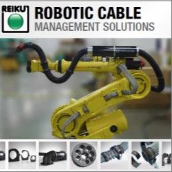
REIKU's Cable Saver™ - The Most Versatile Modular Robotic Cable Management Solution
REIKU's Cable Saver™ Solution eliminates downtime, loss of revenue, expensive cable and hose replacement costs, maintenance labor costs. It's available in three sizes 36, 52 and 70 mm.
All of the robots cables and hoses are protected when routed through the Cable Saver™ corrugated tubing.The Cable Saver™ uses a spring retraction system housed inside the Energy Tube™ to keep this service loop out of harms way in safe location at the rear of the Robot when not required. The Cable Saver™ is a COMPLETE solution for any make or model of robot. It installs quickly-on either side of the robot and has been tested to resist over 15 million repetitive cycles.
REIKU is committed to providing the most modular, effective options for ensuring your robotic components operate without downtime due to cable management.
www.CableSaver.com
